  |
Victoria's Burnside Gorge neighbourhood in 1912: A community heritage project
This public history project focuses on the Burnside Gorge neighbourhood in Victoria, British Columbia. It was developed in conjunction with the Burnside Gorge Community Association [BCGA], to mark the 150th anniversary of the incorporation of the City of Victoria (1862-2012).
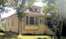
We identified, photographed, and described the architectural features of residential dwellings that were built in 1912 or earlier.
In addition, we created created biographies for over one hundred households using nominal data from the 1911 census and other historical records.
For a comprehensive list of the building biographies, with photographs and information who lived in these places a century ago, see the index of Burnside Gorge heritage properties.
We now have a heritage geographical information system [GIS] that can be used by residents and researchers.
I used mapping software from ESRI Canada, ArcGIS Online, to create the Burnside Gorge heritage map.
Brigitte Clark, former Executive Director of the Victoria Heritage Foundation, used ArcGIS StoryMaps to create an interactive map and walking tour of historic houses in this neighbourhood.
This engaging feature is entitled Burnside-Gorge Heritage Tour.
If you have suggestions on how to develop our public history project further, or examples of similar projects in other cities, please contact me at
dunae@cliomedia.ca.
Patrick A. Dunae
Adjunct Associate Professor, Department of History, University of Victoria/
Volunteer, Burnside Gorge Community Association